
How Safe Are Topographical Land Surveys London? A Professional Guide for 2026
Understanding Topographical Land Surveys London
Topographical surveys are an essential component of land planning and development in London and Surrey. These surveys provide a detailed map of natural and man-made features on a parcel of land, helping architects, engineers, and developers to make informed decisions about their projects. As urban areas become increasingly congested, the need for accurate and comprehensive data becomes ever more critical. When exploring options, topographical land surveys london present a wealth of information that can significantly impact the success and efficiency of your project.
What Constitutes a Topographical Survey?
A topographical survey is a precise representation of the features of a specific area of land. This type of survey typically includes details such as:
- Elevation changes and contours
- Water bodies like rivers and lakes
- Roads, pathways, and structures
- Trees, vegetation, and other natural features
- Utilities and any other man-made elements
The data collected during a topographical survey is used to create a scale-based map that serves as a reference for various planning and construction activities.
Importance of Accurate Land Surveys for Planning
Accurate topographical surveys play a crucial role in the planning stage of development projects. Here are several reasons why:
- Informed Design: Architects and engineers depend on accurate data to create designs that harmonise with the terrain, ensuring that new constructions can withstand environmental factors.
- Risk Management: By illuminating elevation changes and potential hazards, surveys can help mitigate risks associated with flooding, landslides, and other environmental issues.
- Regulatory Compliance: Local authorities often require topographical surveys as part of the planning application process, ensuring that developments comply with zoning laws and environmental standards.
Who Requires Topographical Surveys in London?
Topographical surveys are used by a wide range of professionals, including:
- Architects: To inform design decisions and ensure structural integrity.
- Engineers: For civil engineering projects, where precise measurements are vital.
- Developers: To assess land suitability for construction or other developments.
- Landscape Architects: When planning outdoor spaces that integrate with the existing landscape.
- Local Authorities: For environmental assessments and planning applications.
Benefits of Topographical Surveys for Development Projects
Utilising topographical surveys can bring significant advantages throughout the lifecycle of a development project.
How Topographical Surveys Support Design Goals
Accurate site data derived from topographical surveys enables architects and engineers to create designs that align with the natural environment. This practice not only enhances aesthetic appeal but also ensures functionality in various aspects, including:
- Drainage systems that work harmoniously with local topography
- Building designs that consider wind patterns and sunlight exposure
- Access routes that are safe and efficient for construction and maintenance
Identifying Potential Risks and Constraints
Before beginning any construction, understanding the risks associated with the site is essential. Topographical surveys reveal:
- Areas prone to flooding or water accumulation
- Unstable ground conditions that may require mitigation
- Existing structures or natural features that could impact plans
This information allows for better planning and reduces the chances of costly delays or safety hazards during construction.
Enhancing Compliance with Local Planning Regulations
Local councils in London and Surrey often stipulate that topographical surveys accompany planning applications. These documents serve as critical evidence that proposed developments are suitable for the selected sites, addressing potential concerns regarding:
- Environmental impact
- Urban planning integrity
- Community feedback and ongoing development plans
Technologies Used in Topographical Surveys
The accuracy and reliability of modern topographical surveys are ensured through the use of advanced technologies. Here are some of the key tools employed by surveyors in the UK.
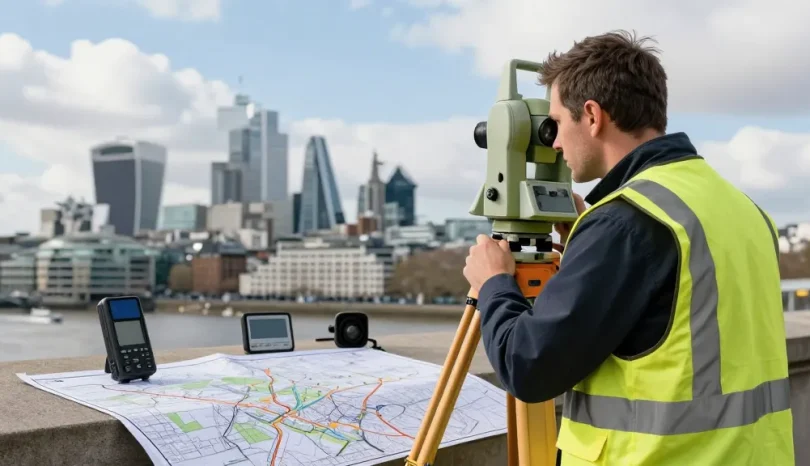
Utilisation of GPS and Total Stations
Global Positioning Systems (GPS) and Total Station instruments are fundamental tools in the surveyor’s toolkit. Total Stations combine the functionality of electronic distance measurement (EDM) with angle measurement, providing reliable data for both horizontal and vertical dimensions.
The Role of 3D Laser Scanning in Precision Mapping
3D laser scanning technology, commonly known as LiDAR, captures millions of data points to create detailed three-dimensional models of landscapes and structures. This technology is particularly beneficial for:
- Mapping complex terrains
- Capturing data for historical preservation
- Facilitating the integration of various features in a digital environment
Incorporating Drone Technology for Accessibility
Drones, also known as unmanned aerial vehicles (UAVs), are revolutionising how topographical surveys are conducted. Equipped with high-resolution cameras and photogrammetry software, drones rapidly capture data from hard-to-reach areas, making them invaluable in:
- Large-scale site assessments
- Documenting changes over time during project development
- Exploration of challenging terrains or elevations
Costing for Topographical Land Surveys London
The cost of a topographical survey can vary significantly based on several factors, which are important to understand when budgeting for your project.
Factors Influencing Survey Pricing
Some of the primary factors affecting the cost of topographical surveys in London include:
- Site Size: Larger areas require more extensive data collection and analysis.
- Complexity of the Landscape: Features such as steep slopes or water bodies increase survey difficulty.
- Required Accuracy: High-precision needs, especially for engineering projects, may lead to higher costs.
Comparative Pricing by Project Size
Generally, survey costs can be broken down as follows:
- Small residential plots: £450 to £750
- Medium-sized commercial plots: upwards of £1,000
- Large infrastructure projects: £2,000 and above
It’s advisable to obtain clear, fixed price quotes to avoid unexpected expenses.
How to Obtain Competitive Quotes
When requesting quotes for topographical surveys, consider providing detailed information about your project, including:
- The size and type of the site
- Specific features or constraints that may impact the survey
- Your required timelines for project completion
By being clear and thorough in your initial communication, surveyors can offer the most accurate and competitive pricing for your needs.
Future Trends in Topographical Surveys
As we move toward 2026, the surveying industry is poised to undergo several significant shifts. Here are some emerging trends to keep an eye on.
Emerging Technologies Shaping the Sector
Advancements in technology will continue to transform surveying practices. Innovations such as artificial intelligence and machine learning are set to improve data analysis, allowing surveyors to extract insights more efficiently from collected data.
Predicted Changes in Regulatory Requirements by 2026
It is expected that local authorities will begin to impose stricter regulations regarding environmental assessments and sustainability in planning applications. This will likely increase the demand for detailed topographical surveys that assess ecological impacts more thoroughly.
Shifting Market Demands in Land Development
As urban areas grow, there is a noticeable shift in the types of projects incoming surveyors will encounter. Increased focus on sustainable and green building practices will influence the information required from surveys in the coming years.
What Are the Common Misconceptions About Topographical Surveys?
Many individuals mistakenly believe that topographical surveys are only necessary for large commercial projects. However, even small-scale residential developments greatly benefit from the clarity and insights provided by comprehensive survey data.
How Can a Topographical Survey Prevent Costly Errors?
Investing in a topographical survey at the outset of a project is a proactive approach that can save time and money. By identifying potential issues, such as unstable ground or flood risks, developers can plan accordingly, preventing expensive rework or project delays down the line.
Are Topographical Surveys Necessary for Small Residential Projects?
Absolutely. Even small residential projects benefit from the detailed site analysis provided by topographical surveys, ensuring that constructions comply with local regulations and incorporate local terrain effectively.
What Equipment is Standard in Topographical Surveys?
Surveyors typically employ a variety of equipment, including:
- GPS units for accurate positioning
- Total stations for measuring angles and distances
- 3D laser scanners for capturing detailed site data
- Drones for aerial mapping and hard-to-reach sites
How Reliable Are Online Quotes for Topographical Surveys?
While online quotes can provide a good initial estimate, they may not always reflect the final price accurately. Be sure to consult with surveyors to clarify details and confirm the scope of work needed for your project.